The Himalayas – the very name evokes images of snow-capped peaks piercing the heavens, ancient glaciers whispering tales of the past, and vibrant cultures humming with tradition. This majestic mountain range, stretching across eight countries in Asia, isn’t just a geographical marvel; it’s a crucible of life, spirituality, and adventure.
A Tapestry of Breathtaking Landscapes:
Imagine soaring valleys carpeted with wildflowers, rugged passes challenging intrepid hikers, and serene turquoise lakes reflecting the grandeur of the peaks. From the towering summit of Mount Everest, the highest point on Earth, to the mystical Annapurna Sanctuary hidden amongst giants, the Himalayas offer landscapes that leave you breathless.
A Cradle of Diverse Cultures:
For millennia, the Himalayas have been home to diverse communities, each with its own unique traditions and ways of life. Explore the colorful prayer flags and intricate monasteries of Bhutan, delve into the rich history of Nepal’s ancient temples, or lose yourself in the vibrant festivals celebrated in the Indian Himalayas. The cultural tapestry woven across this region is as enthralling as its scenery.
An Adventure Seeker’s Paradise:
Whether you’re a seasoned mountaineer or a casual hiker, the Himalayas offer a challenge for every level. Trek through rhododendron forests, embark on challenging expeditions to iconic base camps, or simply enjoy gentle walks amidst breathtaking panoramas. The possibilities for adventure are endless.
Beyond the Peaks:
The Himalayas are much more than just stunning mountains. They are the source of major rivers like the Ganges and Indus, nourishing vast plains and supporting diverse ecosystems. They are home to rare and endangered species, from the majestic snow leopard to the elusive red panda. Exploring the Himalayas means appreciating their vital role in our planet’s delicate balance.
Planning Your Himalayan Journey:
The Himalayas beckon with their promise of adventure, cultural immersion, and breathtaking beauty. When planning your trip, consider the specific region you’d like to explore, the type of activities you’re interested in, and the time of year that best suits your needs. Remember to be respectful of local customs and traditions, and choose responsible tourism practices to preserve the magic of this unique place.
So, pack your bags, lace up your boots, and prepare to be awestruck by the wonder of the Himalayas. This is where earth touches the sky, and where memories are made to last a lifetime.
Unveiling the Layers: A Deeper Dive into the Himalayas’ Physical Wonders
Beyond the captivating landscapes and cultural tapestry, the Himalayas boast a unique geological story written in towering peaks, sculpted valleys, and hidden glaciers. Buckle up as we delve deeper into the physical features that define this awe-inspiring mountain range:
A Stairway to the Heavens:
Imagine the Himalayas not as a single wall, but as a series of parallel ranges rising like stairs. Each “step” boasts its own distinct character:
- The Siwalik Hills: The foothills, home to fertile valleys and bustling towns.
- The Lesser Himalayas: Lush forests and charming hill stations offer refuge from the plains’ heat.
- The Greater Himalayas: Where mighty peaks like Everest and K2 pierce the sky, glaciers carve valleys, and snow paints the landscape white.
- The Tethys Himalayas: A stark, high-altitude plateau bordering the Tibetan Plateau.
Sculpted by Powerful Forces:
The Himalayas are a young mountain range, born from the titanic clash of the Indian and Eurasian tectonic plates. This ongoing collision continues to shape the landscape, creating:
- Towering Peaks: Jagged, snow-capped mountains like Annapurna and Manaslu are a testament to Earth’s immense power.
- Deep River Gorges: The Indus and Ganges, fed by glacial meltwater, carve dramatic canyons through the landscape.
- Vast Plateaus: Like Ladakh and Tibet, offering stark beauty and unique ecosystems at high altitudes.
A Realm of Glaciers:
The Himalayas are home to the third-largest concentration of glaciers outside the polar ice caps. These frozen rivers, clinging to the slopes, are the source of life for millions downstream:
- Valley Glaciers: Flowing down valleys, carving U-shaped landscapes and feeding rivers.
- Hanging Glaciers: Perched precariously on cliffs, adding an element of danger and majesty.
- Icefalls: Where glaciers tumble down steep slopes, creating spectacular displays of power and movement.
A Canvas of Climate Zones:
As you ascend the Himalayas, you travel through distinct climate zones, each with its own flora and fauna:
- Subtropical Foothills: Lush forests teeming with wildlife like elephants and rhinos.
- Temperate Valleys: Home to vibrant rhododendron forests and charming villages.
- Alpine Meadows: Above the treeline, wildflowers paint the slopes in summer, while harsh winters reign.
- Nival Zone: Permanent snow and ice, where only the hardiest plants and animals survive.
Exploring the Physical Marvels:
From trekking alongside towering peaks to witnessing the power of glaciers up close, the physical features of the Himalayas offer endless opportunities for exploration:
- Hike the Annapurna Circuit, traversing diverse landscapes and experiencing different climate zones.
- Raft the Indus River, navigating dramatic gorges carved by millennia of glacial meltwater.
- Visit Nubra Valley, a high-altitude desert plateau offering stark beauty and unique wildlife.
- Witness the Khumbu Icefall, a dynamic and dangerous landscape at the base of Mount Everest.
The Himalayas are more than just mountains; they are a living, breathing testament to the Earth’s dynamic forces. By understanding their physical features, we gain a deeper appreciation for their beauty, power, and vital role in our planet’s ecosystem. So, pack your bags, choose your adventure, and prepare to be captivated by the physical wonders of the Himalayas, where Earth truly touches the sky.
Where Giants Pierce the Sky: Experiencing theAwe of Soaring Heights and Dramatic Depths
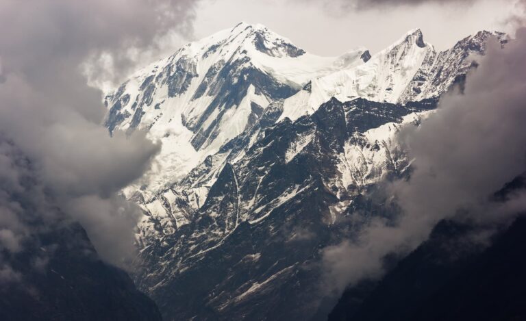
The Himalayas aren’t just mountains; they’re a visceral experience. Imagine standing at the base of soaring heights that stab the heavens, their snow-capped peaks kissed by the sun and shrouded in mystery. Each jagged tooth against the azure canvas is a testament to Earth’s immense power, etched with stories of ancient collisions and sculpted by relentless wind and ice. Look closer, and you’ll see the steep-sided flanks, some smooth and inviting, others a chaotic jumble of rock and scree, all daring the adventurous soul to explore.
But the drama doesn’t end there. As your gaze descends, it plunges into verdant valleys, cradled between these giants. Lush forests painted in emerald hues climb the lower slopes, giving way to meadows bursting with wildflowers in summer. Crystal-clear streams, born from alpine glaciers hidden high above, snake through the valleys, their gentle murmurs a stark contrast to the silent majesty of the peaks.
But don’t be fooled by the serenity. Peer deeper, and you’ll discover the raw power of the Himalayas. Deep river gorges slice through the landscape like scars, carved by the relentless flow of water over millennia. The Indus, the Ganges, the Brahmaputra – all mighty rivers with turbulent histories, roaring through these canyons as testaments to the forces that shaped this land.
The experience is multisensory. Feel the chill of the thin air high above, hear the wind whistling through the jagged peaks, and smell the sweet fragrance of wildflowers clinging to impossibly steep slopes. Witness the sunrise paint the snow-capped summits in a fiery glow, and listen to the thunderous crack of an avalanche echoing through the valleys.
Exploring these soaring heights, steep-sided jagged peaks, valleys, and alpine glaciers, deep river gorges is not just a physical journey; it’s a journey into the soul of the Himalayas. It’s a humbling encounter with the raw power of nature, a reminder of our place in its vastness, and a chance to witness the breathtaking beauty born from immense forces. So lace up your boots, pack your sense of adventure, and prepare to be awestruck by the immensity of the Himalayas, where the earth truly touches the sky and leaves an indelible mark on your soul.
Lifeblood of the Peaks: Unveiling the Major Rivers of the Himalayas
Sure, here are the major rivers that flow through the Himalayas:
Indus River: This mighty river originates in Tibet and flows northwest through Pakistan before emptying into the Arabian Sea. It is the lifeline of Pakistan, providing water for irrigation and drinking to millions of people.
Ganges River: Considered sacred by Hindus, the Ganges River starts in the Himalayas and flows eastward through India and Bangladesh before emptying into the Bay of Bengal. It is one of the most polluted rivers in the world, but it also supports the livelihoods of millions of people.
Brahmaputra River: This transboundary river originates in Tibet and flows eastward through India and Bangladesh before merging with the Meghna River and emptying into the Bay of Bengal. It is a vital source of water for agriculture and transportation in the region.
Salween River: This river originates in the Tibetan Plateau and flows southward through Myanmar before emptying into the Andaman Sea. It is known for its wild beauty and challenging rapids, making it a popular destination for whitewater rafting.
Mekong River: This Southeast Asian giant originates in the Tibetan Plateau and flows southward through China, Myanmar, Laos, Thailand, Cambodia, and Vietnam before emptying into the South China Sea. It is the world’s 12th-longest river and supports a rich biodiversity and diverse cultures.
These are just a few of the many rivers that flow through the Himalayas. These rivers play a vital role in the ecology and economy of the region, and they are also popular destinations for adventure tourism.
Did They Reach the Top? The Long-Standing Debate of Everest’s First Summit
The first confirmed successful ascent of Mount Everest was on May 29, 1953, by Edmund Hillary and Tenzing Norgay. However, there’s ongoing debate and mystery surrounding whether others reached the summit before them.
Several earlier expeditions attempted to climb Everest, with the 1924 expedition sparking the most significant debate. George Mallory and Andrew Irvine made a final summit attempt on that year but never returned. Evidence, including a photograph seemingly taken high on the mountain, fuels speculation they might have reached the top, but the lack of conclusive proof leaves it unsolved.
Therefore, while 1924 remains a possibility, May 29, 1953 stands as the documented and confirmed first successful ascent of Mount Everest by Hillary and Norgay.
Unveiling the Himalayas: Charting the Path from Sketches to Systematic Maps
Attributing the “first known map” of the Himalayas depends on what constitutes a “map” and the level of accuracy you consider significant. Here are two contenders:
1590: Antonio Monserrate, a Spanish missionary in the court of Mughal emperor Akbar, created a sketch map of the Himalayas in 1590. While not highly detailed, it did mark major rivers and mountain ranges with some accuracy. This is often considered the earliest recorded attempt to map the Himalayas.
1733: Jean-Baptiste Bourguignon d’Anville, a French geographer, compiled a more comprehensive map of Tibet and the Himalayas in 1733. This map was based on various sources, including accounts from travelers and explorers, and offered a more systematic representation of the region compared to Monserrate’s sketch.
Therefore, depending on your definition, you could consider either:
- Antonio Monserrate’s sketch (1590): Earliest attempt, but more of a basic outline.
- Jean-Baptiste Bourguignon d’Anville’s map (1733): More comprehensive and based on systematic exploration, but later than Monserrate’s.
It’s important to note that both these maps, and likely others dating back further, existed only in private collections or archives and weren’t readily available to the wider world. The mapping of the Himalayas continued to evolve throughout the 18th and 19th centuries with major contributions from British surveyors and explorers like William Lambton and Andrew Waugh.
From Shadows to Summits: Unveiling the 18th & 19th Century Mapping of the Himalayas
As the 18th century dawned, the mystique of the Himalayas continued to lure intrepid explorers and ambitious cartographers. The British East India Company, recognizing the strategic and economic importance of the region, embarked on several expeditions aimed at deciphering its secrets.
Early Trailblazers:
- William Lambton (1766-1823): Known as the “Father of Indian Triangulation,” Lambton undertook the daunting task of establishing a network of interconnected triangles across India, stretching from Cape Comorin to the Himalayas. His work laid the foundation for precise future measurements.
- James Rennell (1742-1830): A pioneering geographer, Rennell compiled various accounts and surveys, including Lambton’s data, into the first comprehensive “Map of Hindoostan” (1782), significantly shaping European understanding of the Himalayas.
The 19th Century Surge:
The 19th century witnessed a surge in the mapping of the Himalayas, characterized by:
- The Great Trigonometrical Survey: Established in 1802, this massive undertaking continued Lambton’s legacy, meticulously mapping the entire Indian subcontinent, including the Himalayas. Figures like Andrew Waugh, George Everest (yes, the namesake!), and Robert Strachey led the expedition, pushing the boundaries of surveying technology and endurance.
- Exploratory Expeditions: Adventurers like Richard Burton, Henry Godwin-Austen, and Joseph Hooker ventured deep into uncharted territories, collecting crucial data on geography, flora, and fauna. Their firsthand accounts and observations filled in the gaps on the map and painted a vivid picture of the region’s hidden wonders.
- Technological Advancements: The adoption of photography, barometers, and theodolites revolutionized surveying. Capturing breathtaking panoramas and measuring elevations more accurately, these tools enhanced the detail and accuracy of Himalayan maps.
Beyond Borders:
It’s crucial to acknowledge that the story of mapping the Himalayas extends beyond British expeditions. Local communities, traders, and pilgrims contributed their knowledge and navigation skills, shaping understanding of the region’s intricate pathways and landmarks. Moreover, collaborations with Russian, German, and other European explorers provided valuable data and perspectives, emphasizing the collective effort involved in unraveling the secrets of this vast mountain range.
The mapping of the Himalayas is a testament to human curiosity, ambition, and collaboration. From early sketches to intricate surveys, this ongoing process continues to refine our understanding of this awe-inspiring region, reminding us that there’s still much to discover in the shadows of the world’s highest peaks.